
LoRaWAN is a great long-distance, low-power transmission protocol. One of the questions that often comes up after deploying a gateway and nodes is “what’s the greatest distance I can successfully transmit between my gateway and node?” You could watch your Application traffic on The Things Network as you move to strategic locations and see if packets appear. However, an automated approach to this could save time and allow you to cover more ground. To do this, you’ll need a node with a GPS to send its location and software to aggregate the received data on a map to show the node transmission locations. This way you can have the node automatically transmit at a rapid interval as you walk, cycle, or drive to various locations.
TTN Mapper is a web-based mapping software that does this from data transmitted to The Things Network. However, the issue with TTN Mapper is it does not update in real-time, requiring up to a day to see if your transmissions were successfully received. This limits it’s usefulness if you’re trying to determine transmission distance as you’re on the move, such as I like to do while driving. To overcome this limitation, I developed mapping software that receives the location data from The Things Network and displays it in real-time on a map in a web browser on your phone, tablet, or computer. This map can even display your current location if you permit location sharing. The backend of the software runs in a docker container and has been successfully built and tested on both a Raspberry Pi and a desktop PC running a 64-bit version of Ubuntu.
Features
- Multiple map layers, including topology, streets, and satellite (Bing API key required for satellite)
- Automatically acquires new data and adds markers to the map
- Tracking tool to use device GPS to place marker of current position (and direction) on map (requires allowing location permission for browser/phone)
- Scale bar on edge of map
- SSL/HTTPS (required for location tracking)
- Measuring tool for measure distances between points
- Map stays focused on the same point across page refreshes
- Clicking gateway or data point markers pops up information about them
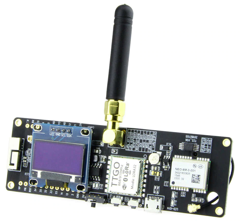
The hardware I chose for the node was the TTGO T-Beam with an OLED display, which I developed tracking software that works for both TTN Mapper and my TTN Tracker software.
More information, including hardware, code, and setup instructions can be found at the following links:
TTGO T-Beam TTN Tracker: kizniche/ttgo-tbeam-ttn-tracker
TTN Web Tracker: kizniche/ttn-tracker
Outdoor LoRaWAN Gateway
Affiliate links
I participant in the Amazon Services LLC Associates Program, an affiliate advertising program designed to provide a means for sites to earn advertising fees by advertising and linking to Amazon.com, and I make a commission for sales made through affiliate links posted on this website.
Hello Sir,
There is a way to add to the ttgo-tbeam-tnn-tracker , a field to monitor the battery level, can you drive in that direction?
Thanks in advance,
Luis Lazo
The T-Beam has battery-monitoring circuitry, so it is possible. I don’t have a need for such a feature, but if you happen to modify the code, please share or submit a pull request on github.
Hello Kyle,
I’m struggling while decoding the payload. I’m getting the right lat, long, alt, sats number at my OLED and at Serial Monitor… But when TTN decodes the payload it returns unrealistic values.
Make sure you’re using the decoder I provide. Review all steps of the setup: https://github.com/kizniche/ttgo-tbeam-ttn-tracker#setup